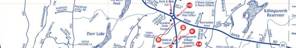


Killingworth, CT Street Map
The most accurate Killingworth town map available online.

The Town of Killingworth, Connecticut, is the quiet crossroads between the Connecticut River, the Long Island Sound, and the I-91 corridor. Rising to an elevation over 600 feet, Killingworth is the highest point within ten miles of the East Coast of the United States between Maine and Mexico.
The Town of Killingworth has a Selectmen-Town Meeting form of government. The First Selectman is the chief elected official and chairman of a three-member Board of Selectman, who collectively serve as the executive branch. The Town Meeting is the legislative body; it is composed of all residents who are registered voters or who own property assessed at $1,000 or more. Numerous specialized boards and commissions of elected or appointed residents have responsibility for specific functions of town governance.
The Town of Killingworth is a chartered municipality and enjoys home rule authority as provided by the Connecticut General Statutes.
For a history of the town, please visit the Killingworth Historical Society.
Visit town website: http://www.townofkillingworth.com
